January 2020 To April 2020 Fuels, Fire and Weather Assessment For Central And Southern California Report Finds Winter Precipitation Expected to be Below Normal for the Rest of Winter into Early Spring
Temperatures Above Normal through March.
Winter Precipitation Below Normal rest of winter into early spring.
Near Normal number of offshore wind events January.
Early onset of spring “grassfire season” possible in April.
Weather Discussion
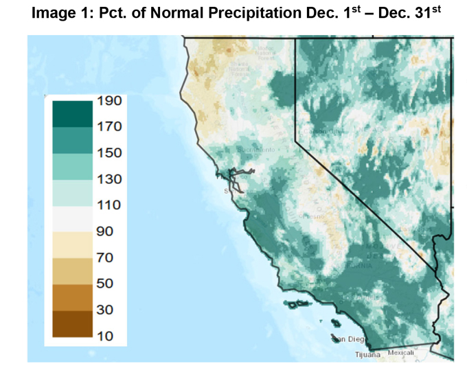
January 2, 2020 – The cool, wet weather pattern which suddenly emerged in November continued into December as several cold-core storm systems visited the state. While a few of these had a subtropical 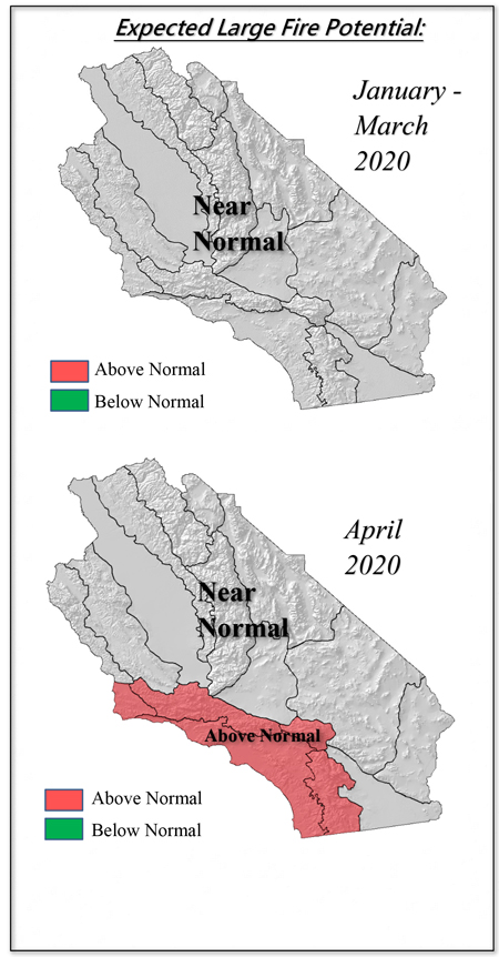 connection, most of the precipitation across Southern California arrived courtesy of storms begat from the Gulf of Alaska. As such, these storms brought heavy snow to relatively low elevations, especially across the Angeles and San Bernardino National Forests. Many of these storms remained off the coast, which caused the heaviest precipitation in Central California to be focused from the San Joaquin Valley westward. While much of the desert continued to see well above normal precipitation last month, curiously, the Sierras experienced slightly below average precipitation in December (Image 1, below).
Offshore wind events were infrequent during the past month and of comparatively weaker strength than the events of October and early November. Temperatures were generally on the cool side which, along with short daylight hours and a low solar angle, allowed for much of the precipitation to recharge subsoils without much waste in the form of evaporation.
This winter seems to be shaping up to be one of those years where there are really no solid clues to ascertain what sort of long range weather pattern may emerge during the next few months. The PNA and NAO indices are flat. The current ENSO index is weakly positive, but continues to trend slowly downward toward neutral.
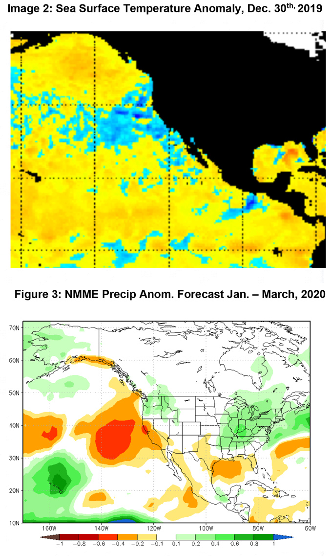
Furthermore, SST anomaly patterns that were seemingly becoming dominant the past few months have recently reversed themselves. The Niño 1+2 region off the South American coast has seen significant warming in December which may negate any chance of seeing a Modoki El Niño from developing this season. But warmer than normal SST’s remain over the Gulf of Alaska, albeit a bit less pronounced and without the large area of spuriously warm water over the Central Pacific compared to last month (Image 2, below).
The majority of long range models had been consistent in showing well below normal precipitation this winter across California and much of the Southwest. The axis of lowest precipitation compared to normal has shifted northward into Northern CA with several NMME members bringing the driest conditions into the Pacific Northwest (Image 3, below). It remains to be seen whether the strong jet stream that we’ve seen this winter will continue to be the biggest player in the weather, or if a blocking (or perhaps split-flow) pattern will eventually win out.
Long range models are still keen on the concept of drier than average weather the rest of the winter with some of the greater deficits occurring in January and February. This is our prediction as well, but forecaster confidence remains lower than normal at this juncture. Temperature outlooks are a bit more clear cut with a high likelihood of warmer than normal temperatures through spring.
FUELS AND DROUGHT OUTLOOK
Widespread, significant precipitation occurring near the winter solstice is usually enough to keep large fire potential low in ensuing weeks and this year should be no exception. The mountains have near or above normal snowpack for this time of year, while lower elevations are seeing rapid growth of seasonal grasses. If the weather turns warm and dry for a period of time during the next month or two, fire spread should be limited to windy periods and confined to elevations above seasonal grass growth, but below the alpine areas which should still have snow cover.
Looking ahead to the late winter and early spring timeframe, if the outlook for below normal precipitation and warmer than normal temperatures come to fruition, grasses may cure out a few weeks early this year. The spike in grass fire activity may occur in April versus May. Thus, if fine fuels become available for ignition earlier this year, there is a greater opportunity for receptive fuels to be present during “offshore wind season” which usually extends from late September into early May. At the current time, all guidance continues to indicate a near normal rate of offshore winds the next few months, but an earlier curing of grasses may allow for a greater opportunity for receptive fuels to be present during a time of year when offshore winds are more prevalent. Therefore, large fire potential may rise to an above normal potential by April over Southern California.
Last year was a very quiet fire season across the western U.S. This summer may be more active across the West and there may be more competition outside of the region for resources. Look for higher preparedness levels nationally with an earlier onset to the 2020 fire season overall. Locally, the highest potential this season (and perhaps for many seasons to come) will likely be in the Sierra Foothills due to a dense stand of bug killed timber. It is too soon to predict whether this will be an active monsoon season, but since storms were so infrequent last year, there will probably be a greater risk of lightninggenerated ignitions compared to 2019.
Source: https://goldrushcam.com/sierrasuntimes/index.php/news/local-news/21508-january-2020-to-april-2020-fuels-fire-and-weather-assessment-for-central-and-southern-california-report-finds-winter-precipitation-expected-to-be-below-normal-for-the-rest-of-winter-into-early-spring